
COLUMBIANA COUNTY
“This Is Where It All Began”
8-10 August 2025
Most county trips begin with crossing over an imaginary border on a nondescript road with nothing in the landscape to distinguish the actual county line. Our entry into Columbiana County was much more dramatic, passing over a major river and a state line. Leaving West Virginia behind us, we drove across the Ohio River on the Wayne Six Toll Bridge, one of the river’s few remaining suspension bridges. It was constructed in 1905 and has been privately owned throughout its lifetime. About 2,000 vehicles pass over it every day.
These kinds of bridges normally make Michele a little wiggy, but she was a trooper as we drove along its 1,590-foot-long steel deck. She even took some photos at my request as we made our way under its metal through truss cage. At the north end, I handed over a dollar bill to the grizzled-looking keeper inside the small toll house.
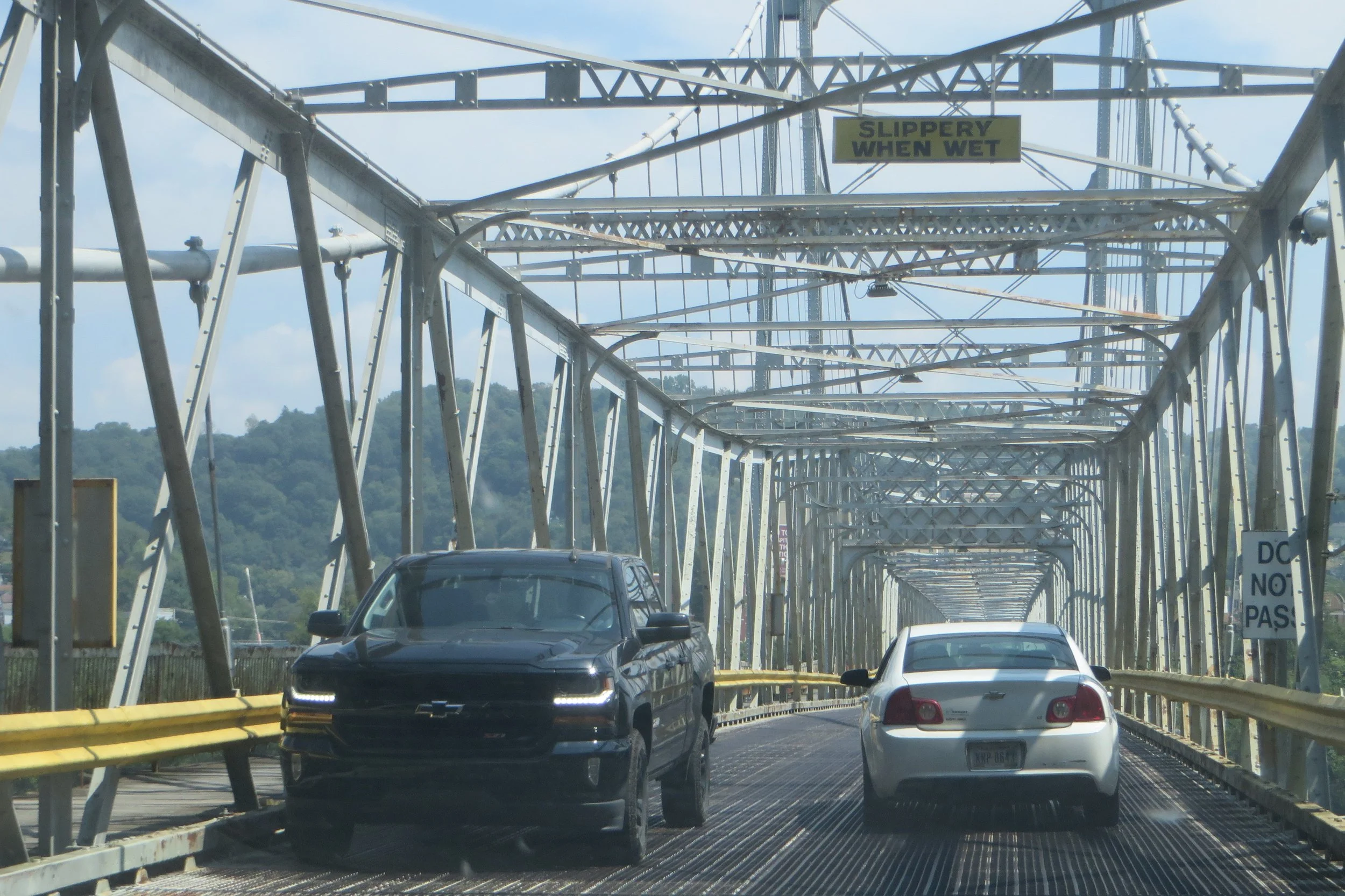
A private bridge over not so troubled water.
The north bank of the river is the official border of the state and county as well as the city of East Liverpool. The bridge lets out onto Golding Street which soon curves in front of the City Hospital and becomes 5th Street. About ten blocks farther east, we parked near our lunchtime destination.
The Potters Bank and Trust Company building was constructed in 1925 of stone and terra cotta with high rounded arched windows in a Beaux Arts Classical style. The structure now serves as a restaurant and community event space known as The Vault. Its cavernous main dining room contains the area’s largest bar and the original big, round bank vault door provides unique décor.
There was a lot to tempt us on the menu. Many of the selections carried financial or locally relevant names such as the Safe Deposit cheeseburger and Potters margarita. I ordered the Pretty Boy Floyd salad (the significance of this name will be forthcoming in the narrative) which consisted of mixed greens, tomatoes, red onion, cucumber, hard-boiled egg, carrots, red cabbage, cheddar cheese, AND French fries, all topped with a house ranch dressing. Michele’s G.O.A.T. salad had spinach, roasted beets, candied pecans, red onions, dried cranberries, goat cheese, garlic, and a lemon vinegarette. Both were delicious and harbingers of a weekend full of delectable meals.
Just a block away, at the corner of East 5th and Broadway Streets, is the Museum of Ceramics, housed in a 1909 post office building. Since we are Ohio History Connection members, we were able to save on the $6 admission fee.
There couldn’t be a more appropriate home for this museum than East Liverpool. Since the first commercial pottery was opened here in 1841, over 200 pottery factories have operated in and around the city. By 1900, the area was producing half of the ceramics in the United States. It truly was “The Pottery Capital of America,” as a nearby historical marker proclaims. It helped that the area was rich with easily accessible clay deposits and that the city was located on the Ohio River for efficient transportation.
The museum does a nice job of detailing the history of the industry with vast exhibits of plates and pitchers, teapots and spittoons, and all other manner of crockery. Another area explains the production process and ends with an interactive computer program where visitors can digitally create and design a piece of pottery. The piece is then “sold” at auction. I suppose the sale price provides a way to evaluate how good your work was. Michele became a little obsessed with this tool, meticulously generating two pieces that each sold for well over 100. (Dollars? Bitcoin? GameStop credits? The software did not specify.) My sole attempt produced a Charlie Brown-like pot that went for a compassionate 69, and even then, I think the program felt sorry for me.
Across the street from the museum, we popped into The Pear Tree Shop, a combination bookstore and local craft emporium. The very friendly lady working there, who enjoyed singing along to the tunes being broadcast in the shop, welcomed us and asked where we were from. Learning we were out-of-towners, she proceeded to provide us with an unsolicited checklist of what we should see and do while we were in East Liverpool. This annoyed me a little, but I quickly let it go. Afterall, she didn’t know that we were on an official county trip and, thus, already prepared with a fully researched and vetted itinerary. We bought a few items before proceeding on OUR way.
Still on foot, we took a look at the nearby Carnegie Public Library. Dedicated in 1902, it’s a grand affair with two stories of brown brick in an Italian Renaissance Revival style. What really catches your attention is the large dome covered in red tiles and topped with a small white cupola. It’s much bigger than most of the libraries Andrew Carnegie endowed, but in this case, his $50,000 donation may have been due to his affection for East Liverpool. He used to spend a couple of weeks here each summer with relatives. The library had already closed for the day so we couldn’t go inside, but we were favorably impressed by the exterior.
We returned to our car and left the downtown behind us as we followed Pennsylvania Avenue to the East End. A couple of turns put us onto Harvey Avenue. Less than a mile farther, past some modest homes and dockside warehouses, we pulled off the road just shy of the state border with Pennsylvania. There we found a group of historical markers that collectively commemorate “The Point of Beginning.” It’s a pretty unassuming locale, but has great significance for the United States.
First, a little history lesson. The Land Ordinance of 1785 was adopted by the United States Congress to set up a standardized system whereby the government could raise funds by selling off undeveloped land in the “west” (that being west of the original 13 colonies). Before they could sell the land, they had to survey it. On September 30, 1785, Thomas Hutchins, the first Geographer of the United States, drove a stake into the ground. That’s where this “Point of Beginning” begins. It was the point where the borders of Pennsylvania, West Virginia (then Virginia), and Ohio converged. Of course, it wasn’t Ohio yet. It wasn’t even the Northwest Territory, from which Ohio would be carved. That area wouldn’t be established for another couple of years. That didn’t stop the surveyors though.
By the way, all these markers and monuments by the side of the road don’t technically mark the Point of Beginning. The original stake has been lost to time. Geographers know that it would have been 1,112 feet south of the monument, but that area is now covered with water, and nobody wants to have to don flippers and a snorkel just to read a historical marker.
With that original stake, though, Hutchins began surveying the six-mile square townships of the Seven Ranges, the first tract in what became the Public Land Survey System. This survey was the prototype for most of the western United States (except Texas) and many other countries of the world. How about that?! It may take a little imagination, but as cars whizzed by me, crossing in and out of Pennsylvania, I allowed myself to feel a little of the gravitas of history.
This passage from Measuring America, by Andro Linklater, makes clear the significance of this seemingly insignificant spot..
“There is nothing to suggest that it was here that the United States began to take physical shape, nothing to indicate that from here a grid was laid out across the land that would stretch west to the Pacific Ocean, and north to Canada, and south to the Mexican border, and would cover more than three million square miles, and would create a structure of landownership unique in history, and would provide the invisible web that supported the legend of the frontier with its covered wagons and cowboys, its farmers and gold miners, and would insidiously permeate the formation into the unconscious mind of every American who ever owned a square yard of soil.”
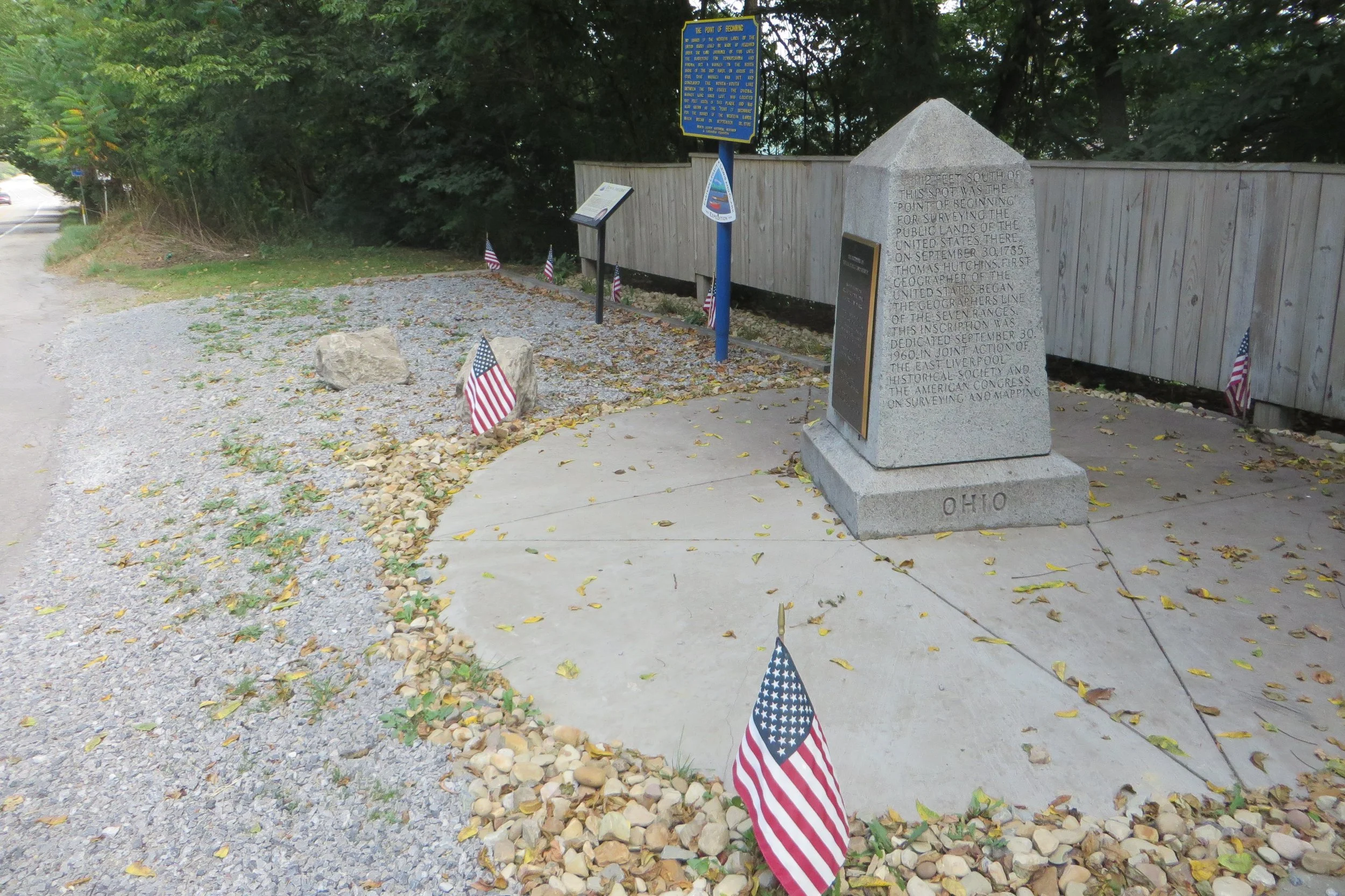
Point of beginning
Not wanting to cross out of the county (and the state!), we backtracked a little before turning onto Park Way, a winding road that heads more or less north. After three and a half miles of meandering curves, we turned left onto Calcutta-Smith Ferry Road and then, a half mile later, right onto Grimms Bridge Road. For the next mile and a half, the two-lane, bermless township road, with sections of its asphalt edges crumbling away, made a constant descent down to Little Beaver Creek and to Grimms Bridge that spans it.
It may seem like an awfully out-of-the-way spot to travel just to see an old bridge over a remote waterway, but a finely engineered structure that’s been in place for over 140 years sometimes deserves a detour.
The 155-foot-long Grimms Bridge was constructed in 1884 by the Wrought Iron Bridge Company of Canton, Ohio. It incorporates a Whipple through truss design with a tall metal frame consisting of a symmetrical lattice of support bars. Its metal grate deck allows only one lane of traffic at a time. I always find it rewarding to see one of these 19th century relics still in use.
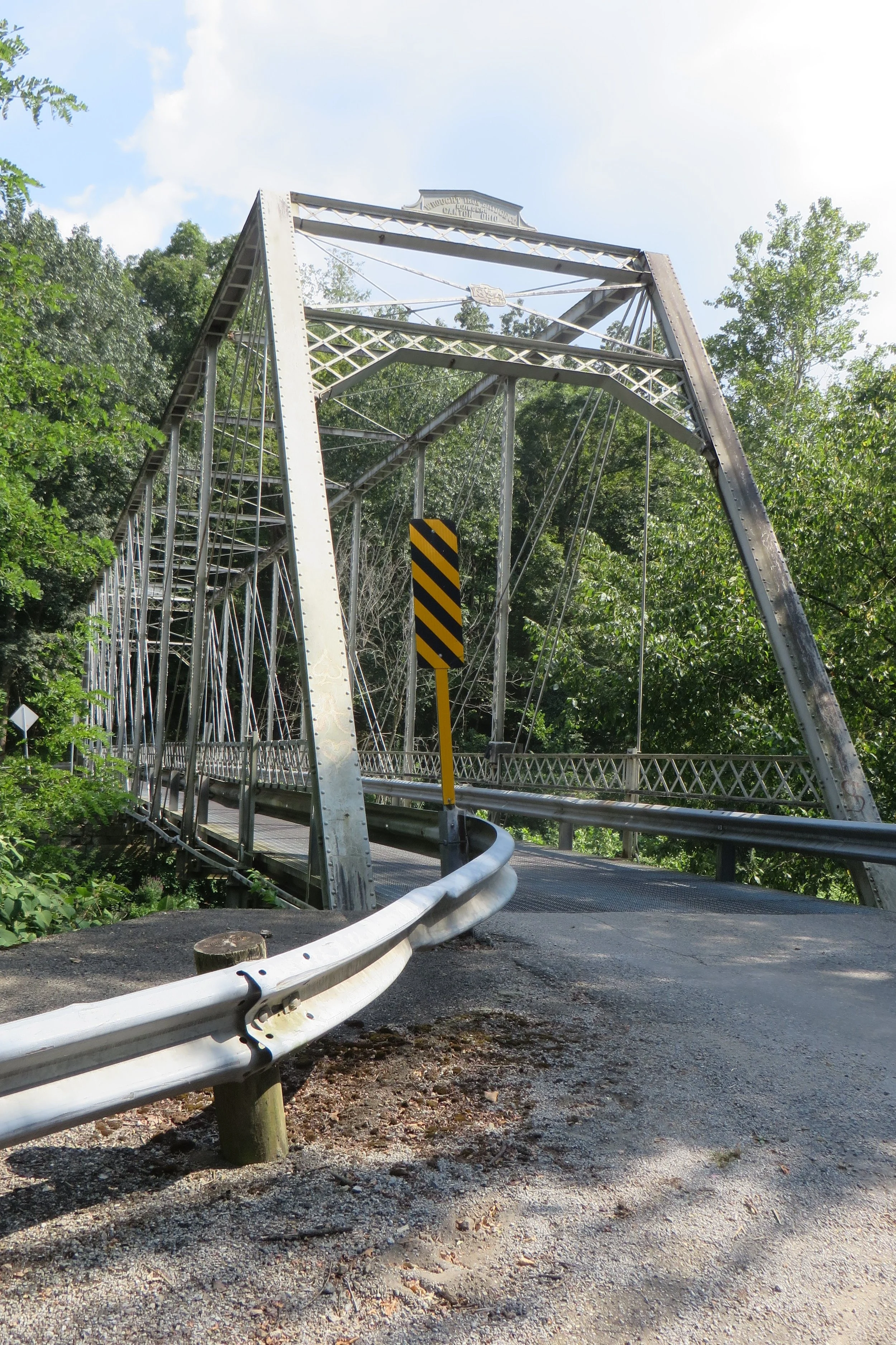
The 155-foot-long Grimms Bridge was constructed in 1884
We backtracked up Grimms Bridge Road and continued northwest on Calcutta-Smith Ferry Road for a short distance before turning north onto Sprucevale Road. A few miles on, we entered Beaver Creek State Park. After crossing over Little Beaver Creek, the road began to rise. We came upon an historical marker that stood out atop a knoll on our left. This backcountry spot was where the Depression-era criminal known as Pretty Boy Floyd met his demise.
The 1930s was a swell time for giving murderers and gangsters catchy nicknames such as Baby Face Nelson and Machine Gun Kelly. (Years later, American singers would usurp these monikers.) If you wanted to gain notoriety, it wasn’t enough to just rob and kill people, you also needed an endearing sobriquet. Pretty Boy Floyd was just another example.
Born Charles Arthur Floyd in 1904 in Georgia, he was known mostly as Charley or Choc to his friends. He grew up in Oklahoma and was arrested for the first time at the age of 18. Over the next 12 years, he continued a life of crime, robbing banks and reputedly murdering a dozen people. Following the death of John Dillinger in 1934, the FBI moved Floyd’s name to the top of their most-wanted list, Public Enemy #1. He only held that distinction for three months.
While attempting to return to Oklahoma from Buffalo, New York, Floyd and another desperado got into a gun fight with Wellsville police, in southern Columbiana County. Floyd escaped that battle, but three days later, on October 22nd, he was found by a group of FBI agents and East Liverpool police on what was then a farm owned by Ellen Conkle. Another gun battle ensued and Floyd was shot multiple times and killed. His body was placed on public display in East Liverpool before being returned to Oklahoma for burial.
I took a picture and thought upon the saying, “crime doesn’t pay.” Perhaps not, but if you have a catchy nickname and command enough newsprint, you may just earn an historical marker in eastern Ohio memorializing your exploits.

Sometimes crime pays… for a historical marker.
We continued north on Sprucevale Road before turning left onto Clarkson Road. After crossing Ohio Route 7, we continued west on Greenwood Road and then on Middle Beaver Road. A mile later, we turned south on Lusk Lock Road, which isn’t much more than a rough single lane path. A sign warns, “No winter maintenance.” I would venture to guess there’s not much upkeep in the summer either. After a half mile of following Pine Run, the road ends at a parking lot.
Just off to the left is the start of a short quarter mile trail that leads to Lusk’s Lock. Back in the first half of the 19th century, canal building was all the rage. The Ohio and Erie Canal, built in the 1820s and 30s, was a north-south transportation route in the eastern half of the state that connected the namesake river and lake. Folks a little farther east wanted an easy connection to it, so a side spur -- the Sandy and Beaver Canal -- was suggested. Construction on it was completed in 1848. Unfortunately, timing is everything, even in canal building, and the waterway was abandoned only four years later. There were some structural problems which didn’t help, but the main problem was the emergence of the railroad as a quicker and more efficient form of transportation.
Lusk’s Lock (Lock No. 27) was one of 90 locks built along the 73-mile-long canal. More than a century and a half later, it remains intact and spectacular in a ravine of the Little Beaver Creek. Its massive stone walls are impressive examples of utilitarian engineering. The Ohio Department of Natural Resources describes the structure with a double-curved stone staircase at one end as “arguably the most artistic lock on the canal.” I wouldn’t argue. The trail that reaches the lock also follows a pretty stretch of the river.
After returning to Middle Beaver Road, we continued west and north on the looping road for two and a half miles before pulling into a parking lot next to a nearly 200-year-old barn and the Church Hill Road Covered Bridge. The former has housed several restaurants, most recently Elkton’s Pub, but it’s currently vacant.
While a rarity, covered bridges still exist in numbers that allow you to see one in Ohio without having far to travel, so you might think with a yawn, “Okay, another covered bridge,” but the Church Hill Covered Bridge has the distinction of being the shortest covered bridge in the United States. That’s what they claim anyway. It was built in the 1870s with a simple two-panel king post truss design and is only 19 feet, 3 inches long. It originally spanned Middle Run, but was moved in 1982 to this attractive park setting next to the Elkton Township Tourism Bureau and Museum.
From the covered bridge, we were able to follow Ohio Route 154 the remaining three and a half miles into the county seat of Lisbon. Its population of about 2,500 residents only allows it village status, but it has the enviable attribute of being located in the center of the county. Our lodging for the weekend was in the north part of town on the corner of Market and Prospect Streets. Known on Airbnb as Pippy’s Pretty Brick Palace, it gave us the run of a large four-bedroom house. After dropping off our bags and getting a cursory lay of the land, we were back out on the road in search of dinner.
Only a mile away, in the south part of town along Ohio Route 45 and next to Little Beaver Creek, sits Pondi’s Restaurant & Bar. We arrived to find the parking lot crowded and folks standing out on the front porch, so we weren’t surprised to learn there was a wait for a table, but the 5-10 minutes it took for us to be seated is hardly worth mentioning. Considering the meal we eventually experienced, a far longer wait would have been worth it.
The waitstaff were kept hopping, but worked quickly while retaining a good-natured amiability. Michele ordered the Bruschetta Chicken Salad while I opted for the Fried Seafood Sampler which came with two shrimp, two fried scallops, and a large piece of cod, as well as two side dishes. It may have been the best cod I’ve ever had. That might have been expected had we been in Lisbon, Portugal (where you can also find a cod museum that’s well worth a visit: https://www.visitlisboa.com/en/places/interpretative-center-of-the-history-of-cod ), but it came as a pleasant surprise in Lisbon, Ohio. Not only was the food delicious, but the portions were generous and the prices were reasonable. That might explain why Pondi’s has been around for over a century. It’s had only four owners since John and Annie Pondi began serving meals in 1916.
After stuffing ourselves, we returned to our Airbnb where we retired for the evening.
The following morning, after a pot of coffee “at home” to get us started, we drove to the center of Lisbon where we found a Farmers Market set up around the town square. Before checking it out, we popped into Nourish Coffee + Kitchen for some breakfast. Kenzie Kauffman opened the eatery in late 2023 with the goal of serving “high-quality food and drinks made with fresh ingredients sourced as locally as possible.” Michele’s omelet and my Cajun breakfast sandwich and chai latte were evidence that she knows what she’s doing and she’s doing it well.
After our meal, Michele went off to peruse the various stalls of the Farmers Market while I walked around and took a few pictures. I began with the Columbiana County Courthouse which dominates the downtown. The 2-story Italianate style structure was built in 1870-71 of smooth stone with high rounded arched windows. A square clock tower rises in the middle and is topped by a statue of Lady Justice.
Just a block west of the courthouse is the Hamilton building, a 3-story brick structure that is purported to be the oldest brick building in Ohio. There’s a plaque on its façade attesting to the fact, so it must be true. It was constructed in 1803 by Jacob Picking for hotel purposes. The marker also explains that Edwin Stanton, Secretary of War under Abraham Lincoln, practiced law in an upstairs office.
I met back up with Michele at one of the market stalls just as the serene Saturday morning was disrupted by the driver of a stopped pickup truck who shouted, “Fuck you!” at the driver ahead of him. He was upset because the traffic light was green, but the car ahead wasn’t moving. The reason was that a pedestrian was crossing against the light and the driver wisely didn’t want to run him over. The participants of the market, both vendors and customers, and made up mostly of middle aged women, loudly reprimanded the pickup driver. Even after having it explained to him what was holding up traffic, he doubled down and continued to vulgarly complain, but the other pedestrians were having none of it and berated him in return, but without any profanity. He had to wait through another cycle of the traffic light, all the while being soundly rebuked from the sidewalk. I’m sure he was relieved when he finally was able to escape around the corner.
Michele and I made wishes and tossed a couple coins in the town square fountain before returning to our vehicle and -- while strictly adhering to all traffic laws and giving all pedestrians a wide berth -- driving out of town.
We followed Ohio Routes 517 and 558 through the northeast quarter of the county. Its rolling hills, pastures, and farm silos ticked all the boxes for a bucolic country road. Thirteen miles later, we entered East Palestine, a village little know outside its neck of the woods before a 2023 train derailment brought it to national attention.
We drove north up its main drag of Market Street before turning east onto Taggart Street because, well, by personal law, I have to check out any road that bears my surname. We followed Taggart to the eastern edge of town and right up against the state border with Pennsylvania. A stubby brick column erected by the local Kiwanis marks the state line.
We then backtracked a few blocks to the corner of Taggart and Pleasant Streets so I could have Michele take a picture of me with the street sign. This intersection is only a block from the railroad tracks where 38 railcars derailed on February 3, 2023. Hazardous materials were contained in 11 of the cars and 3 of those had flammable and combustible materials. After a fire ignited, a controlled burn was conducted to prevent an uncontrolled explosion. About 100,000 gallons of hazardous materials were dumped including vinyl chloride, benzene residue, and butyl acrylate. I don’t know what all those are, but they just sound nasty and toxic. By October of that year, more than 167,000 tons of contaminated soil and more than 39 million gallons of tainted water were removed from the derailment site. More than a year after the accident, higher than normal levels of various pollutants were still evident in air and water analyses. As picturesque as East Palestine is, facts like those keep a visitor from wanting to stay too long.

Taggart street proudly on display just one block from the East Palestine train derailment of 2023.
We departed northbound along State Route 165 as far as the community of Unity and then westbound along State Route 14 into the city of Columbiana. Just west of State Route 7, and short of the county line, we found the Shaker Woods Festival, an annual arts and crafts gathering of over 200 juried vendors. Parking in vast adjacent fields is free, but admission to the festival is $10. This was the 44th year that festivities were held in a patch of woods where permanent individual wooden booths house the crafters.
Our visit was on the first day of the first of three consecutive weekends of the festival. If the number of spectators there during our visit was any indication of future attendance, the festival sponsors were sure to bring in a boatload of money. It had the feel of a fair with busloads (literally) of folks roaming the grounds. We began with a strategic circular route around the outer ring of vendors, and even that seemed to take forever.
The wares on offer ran the gamut from what you might expect, such as Shaker brooms, handmade soaps, pottery, and blown glass, to custom made knives, handmade wooden furniture, and metalwork lawn ornaments. But so much more, too.
The booth that caught our fancy was called Hotplates By MAC and featured the most unique style of trivets, trays, and table runners I’ve ever seen. The design consists of a series of clear square plastic tubes filled with a variety of colorful items ranging from pastas and seeds to beans and grains. Each accessory can bear hot dishes up to 400 degrees. We ended up plunking down $90 for a tray containing 15 varieties of seeds. Until we can use it at our next dinner party, it sits on our kitchen counter as a special piece of art.

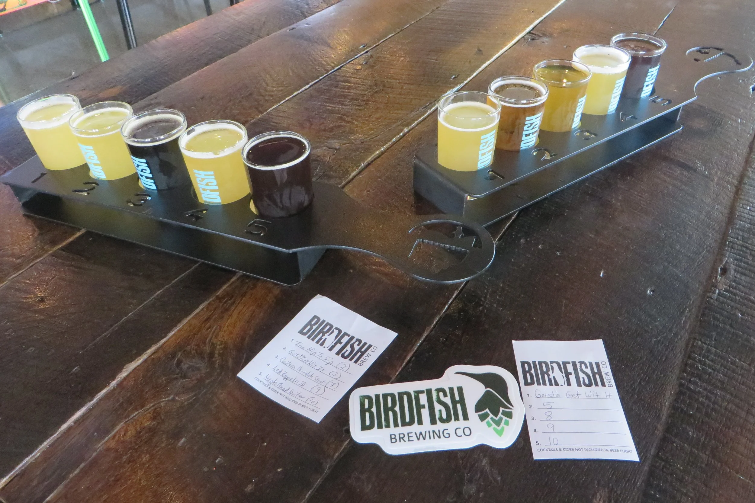
After a lengthy time spent on our feet walking around the festival, followed by a long walk in the sun back to our car, it helped that the next item on our county itinerary was a brewery & taproom. We drove deeper into the city, past Firestone Park on East Park Avenue, before arriving at Birdfish Brewing Company. (By the way, you’ll find a lot of Firestone-branded places in Columbiana as it is the birthplace of tire and rubber magnate Harvey Firestone.)
Michele and I took our time looking over the diverse choice of beers on tap before each selecting our 5-beer flights. We sipped our way through them over the course of the following hour and didn’t find a dud in the bunch. I began with the flavorful Gotsta Get Wit It, a Belgian white ale brewed with lemon, grapefruit, and orange peel, before working my way through the Cowtown chocolate milk stout and the Too Hip To Sip hazy IPA. Not only did they all taste good, but the increasing alcohol content provided some pleasant ass-kicking. The final two were the hoppy Zed Lupulin III hazy triple IPA and the dark and strong Hi-Quad Drifter, a Belgian quadruple ale. Their alcohol content weighed in at 9.9% and 10.4% respectively.
Beer
I love the “third place” characteristic of the modern taphouse; welcoming to all regardless of age, orientation, identity, and species (dogs welcome!). Sometimes, though, I regret that inclusiveness. Near our table was a mother with two young children, including a toddler with a propensity to emit a high piercing shriek every minute or two. You’ve heard of beer goggles. If only our alcohol consumption could have produced beer earplugs.
To give ourselves a little more time to sober up, we moved into the game room, where a selection of arcade games is available, and caught the final 15 minutes of live music from Eri Snowden-Rodriguez, a Venezuelan-American cellist.
With a pleasing afternoon beer glow about us, we left Birdfish and Columbiana and continued our way west for a few miles to the village of Leetonia. Our stop there was brief, just long enough to see what was left of what was once the largest complex of brick beehive ovens in North America. The kilns were used to produce coke that was in turn used as fuel in the manufacture of iron and steel.
There was a huge demand for iron after the American Civil War and the hills around Leetonia were rich in the coal and ore important in producing coke. From 1866 until 1930, the Leetonia Iron and Coal Company (later known as the Cherry Valley Iron Works) operated the ovens – 200 at their peak – that produced enough coke to make 40,000 tons of miscellaneous iron products every year. The remnants of these ovens can still be easily seen in a park on Cherry Valley Road. Each oven was constructed of 6,800 foundry bricks and set inside a foundation of quarried bedrock.
After a few pictures, and with the afternoon waning, we continued west for a few more miles to Salem, the largest city in the county with about 12,000 residents. It holds the historical distinction of being the home to the first statewide Women’s Rights Convention, which was held in 1850. At that gathering, the first attempt was made to change Ohio’s constitution to allow women the right to vote. The convention was convened and led by women only. (Despite constant pressure and promotion, it would take another 70 years before Ohio women gained the right to vote thanks to the ratification of the 19th Amendment to the United States Constitution.)
The Quaker community in Salem provided strong support for women’s suffrage as well as the abolition of slavery. One member, who was born in 1835, and who grew up just a few miles from Salem, was Edwin Coppock. (Fun fact: He was eventually expelled from the church for refusing to give up dancing!) His strong abolitionary beliefs led him to John Brown and eventual participation in the 1859 raid on Harpers Ferry. As a result, he was tried and convicted of treason, murder, and fomenting a slave insurrection, and was hanged along with six others including Brown.
We visited Coppock’s grave in the north part of the city. Coppock was first interred in the town of New Garden, about 10 miles away, but was reburied in Salem’s Hope Cemetery in 1888. The 12-foot-tall monument originally contained only his name and dates of birth and death, but in 1935 a plaque was added with more detail, including the quote, “A martyr to the cause of liberty.”
Back in the center of Salem, on East State Street, we pulled into the parking lot of the Salem Public Library. This is another public library building that was made possible by a generous $20,000 donation from Andrew Carnegie. It was completed in 1905 with a classical pediment above the entrance supported by four tall ionic columns.
With internal dinner bells going off in our heads, we drove a few blocks west to South Broadway Avenue and found Ezio’s Italian Restaurant. For a half century, this family-owned restaurant has been serving up traditional dishes made from authentic family recipes and using local and organic ingredients. It’s hard to go wrong with Italian cuisine, but I wasn’t expecting just how right it could be.
Michele ordered the Francobello, a dish of “Frank’s famous Bolognese sauce” with ricotta cheese and tossed with rigatoni pasta. I chose the Spicy Chicken Penne entrée which had grilled chicken breast and baby peas tossed with penne pasta and spicy Mafalda sauce. We both kept shaking our heads in disbelief over how outstandingly good our dishes were. Ezio’s states on their website that they have the best Italian food in Salem. I believe it!
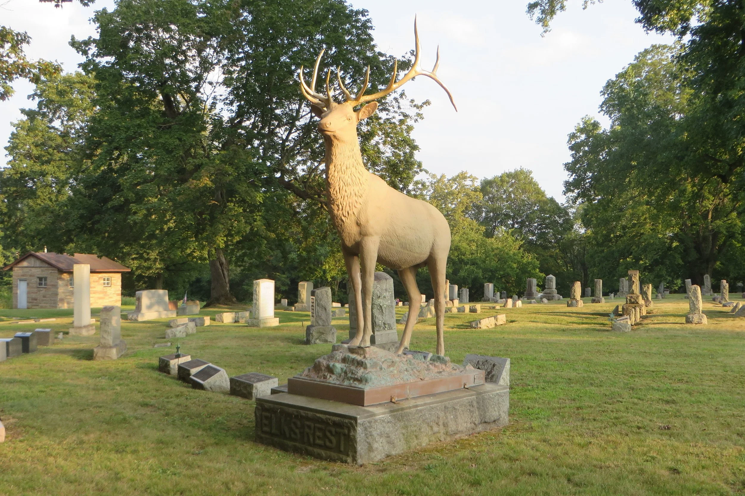
After dinner, we drove south of town on Franklin Street to the Grandview Cemetery. This time, we weren’t in search of a grave, but rather pubic art. One hundred years ago, Salem was home to the W.H. Mullins Art Metal Works, a manufacturer of large bronze and copper statuary. One of the company’s outstanding sculptors was Swiss-born John Segesman, who moved to the United States when he was sixteen years old. Over the thirty years he worked for Mullins, he produced an array of monuments that are now scattered throughout the United States as well as Central and South America. His works included numerous war monuments including many at the Gettysburg National Military Park, statues of Abraham Lincoln, many of which were installed along the Lincoln Highway, and statues commissioned by world leaders that wound up in Haiti and Guatemala.
As grandiose as those projects may have been, Segesman was also popular for a sheet-copper elk statue that was marketed to fraternal organizations throughout the Midwest and New England. It was one of his elks that we found near the southeast corner of Grandview Cemetery. The life-size, eight-foot-tall metal elk will forever elude hunters as it majestically stands erect with its twelve-point rack.
We finally left Salem behind us, traveling southbound on Lincoln Avenue, also known as Ohio Route 45. Four and a half miles later, we turned southwest onto Teegarden Road and then, after another mile and a half, south onto Eagleton Road. That led us to the Teegarden-Centennial Covered Bridge. The 66-foot-long span was built in 1876 primarily of white oak. It carried vehicular traffic over the Middle Fork of the Little Beaver Creek until 1992 when it was bypassed by a new concrete structure. The original bridge, however, is still available for pedestrian passage.
We parked in a lot across the road and I strolled over for a closer look. The bridge was restored in 2003. Repainted over its north entrance is an advertisement for C.R. Phillips, an early Salem drugstore. The interior boards are colorfully adorned with writing. If graffiti were a protective wood preservative, there’s no doubt this bridge will last at least another century.
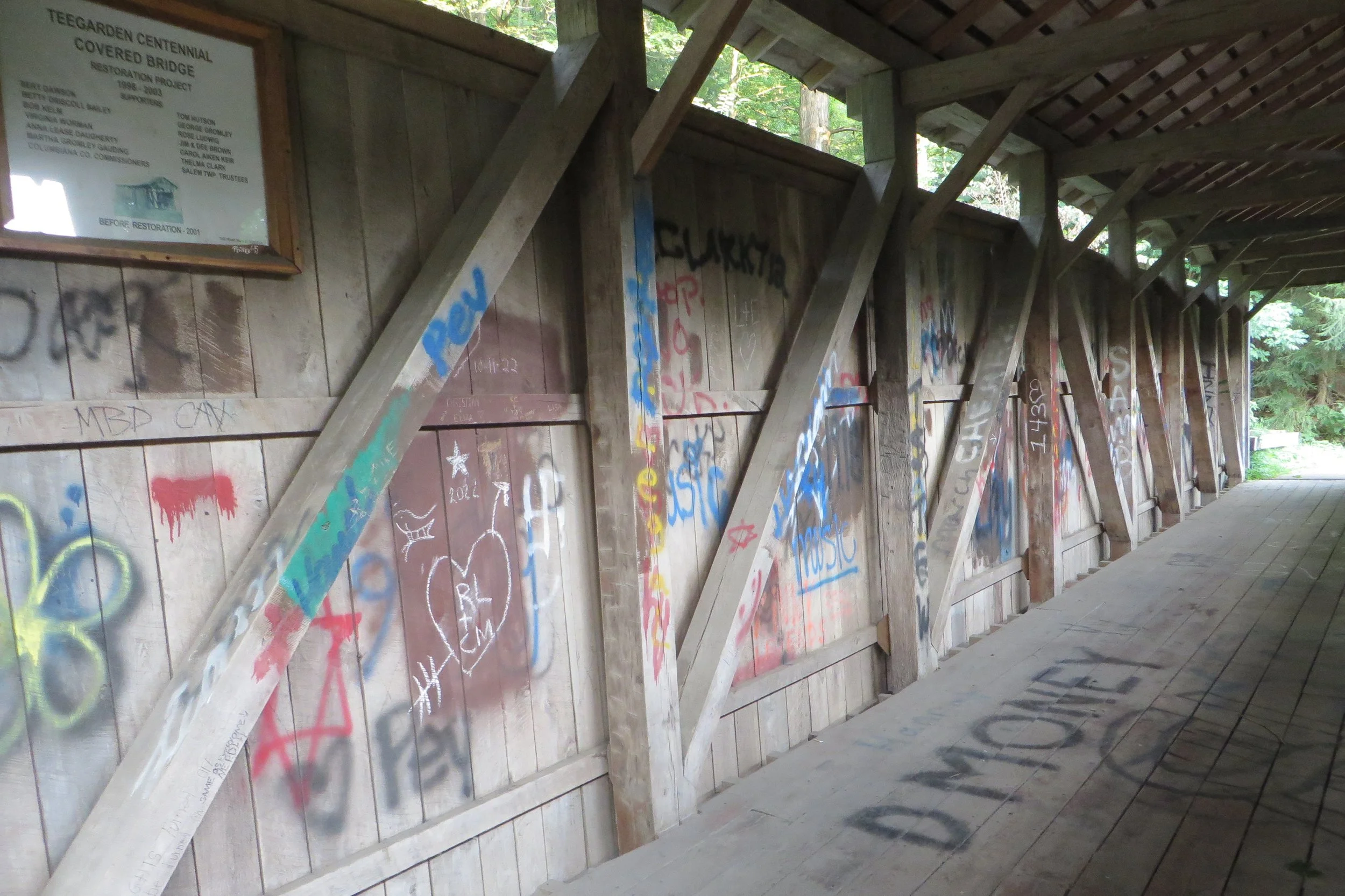
The Teegarden-Centennial Covered Bridge was built in 1876. Sadly, RL and CM broke up later that year after the fall harvest.
We made our way back to State Route 45 in hopes of spotting the Columbiana County Bicentennial Barn. While we did find the barn, just south of St. Jacobs Logtown Road, it is no longer emblazoned with Ohio’s bicentennial logo. After being painted in 2003, it was still there as recently as May of 2024, according to the street view image on Google Maps, but the barn appears to have been resided since then. Timing, it’s everything! With a faint hint of disappointment in the air, we drove on to Lisbon for another night in Pippy’s Pretty Brick Palace.
We slept in on Sunday, but still managed to give ourselves enough time for a morning pot of coffee before we had to checkout of our Airbnb by 11 a.m. We departed Lisbon to the south along Ohio Route 45. It was a pleasant morning with plenty of sunshine and few cars on the road. Traffic dropped even more when we turned onto Ohio Route 518. Farms became more prevalent and the road a little more winding. We pulled into the gravel parking lot at P&C Industrial Services as it was the closest spot to the historical marker I wanted to check out. If I hadn’t known it was there, I could easily have driven right past it.
Friends sometime ask us what there is to see or do on a county trip and Michele has been known to comment (with a hint of sarcasm), “There’s always going to be a rock with a plaque on it.” Our stop on this remote strip of OH-518 was to see one such example.
In 1863, during the American Civil War, Confederate General John Hunt Morgan led a raiding party of nearly 2,500 men through Kentucky, Indiana, and Ohio. It was meant to spread fear in the North and distract Union troops from other campaigns. It’s debatable whether it succeeded in any sense beyond delaying the inevitable.
Over the course of 1,000 miles and about a month and a half, Morgan’s troops were slowly diminished after a succession of skirmishes with Union forces, home guardsmen, and militia units. Finally, on July 26, 1863, with fewer than 350 men left under his command, Morgan gave up the fight. As the plaque reads, “This stone marks the spot where the Confederate Raider Gen. John H. Morgan surrendered his command to Maj. George W. Rue…and is the farthest point north ever reached by any body of Confederate troops during the Civil War.” [Note: There was the St. Albans Raid that occurred in Vermont in 1864 by 21 Confederate soldiers who came down from Canada, but we’re going to ignore that.]
Apparently, Columbiana County isn’t a good place for desperados to linger as both Morgan and Floyd learned too late.
We continued west on OH-518 for about five miles, but then instead of following a curve in the road that would have kept us on the state route, we continued straight onto Gavers Road. After another five miles, we connected to US Route 30 which led us into the village of Hanoverton.
This tiny community of only 350 people has an amazing collection of early- to mid-19th century brick Federal style buildings. Many of them are on Plymouth Street including the 1837 Spread Eagle Tavern. A wood-frame saltbox building that adjoins the tavern was built even earlier. When we arrived there for lunch soon after it opened at 11:30 a.m., we found the hostess harried with phone calls for reservations. We felt fortunate to be given a table.
The interior décor is what I would term “frontier rustic.” The lighting is dim, wide-open hearths are adorned with large cast iron kettles, and long barrel rifles hang over the fireplaces. But make no mistake, similarities to early settlement life stop there. Don’t expect squirrel on the menu.
Our table was covered by a white tablecloth and we were provided with linen napkins and more cutlery than I knew what to do with; two forks, a spoon, a dinner knife, and a butter knife, not to mention the soup spoon and serrated knife that were given me as my courses arrived. I began with a delicious cup of cheese soup with chorizo before moving on to a tender piece of melt-in-my-mouth prime rib, one of the day’s specials. Michele was equally happy with her turkey and gruyere quiche. We often eat well on our county trips, but the restaurants we visited in Columbiana County were all incredibly outstanding.
Five miles northeast of Hanoverton is Guilford Lake State Park, an artificial reservoir that was created in the 1830s to serve as a feeder for the Sandy and Beaver Canal. The area was purchased by the State of Ohio in 1927 and dedicated as a state park in 1949. We stopped by its north shore and while we didn’t make use of any of its amenities, we spotted a couple of boaters on the water and quite a few people enjoying the sandy beach either for tanning or excursions into the water for swimming and floating. A nearby kiosk offered free life vests for short term use.
To the south of the lake, Ohio Route 172 runs east and west. We turned westbound onto it and ten miles later, after passing through the unincorporated communities of New Garden, New Alexander, Chambersburg, and Moultrie, we exited the county.
Time spent in the county: 49 hours, 29 minutes
Miles driven in the county: 130 miles