
LAWRENCE COUNTY - “Flowers, Furnaces, and Phenoms” 17-19 April 2026
If the shape of Lawrence County were presented to me as a Rorschach inkblot, I’d say it strikes me as a wonky steamship with a single smokestack and a sagging hull that dips into the Ohio River. It’s fitting that the shape has a nautical connotation as the county was named for James Lawrence, a distinguished officer in the United States Navy during the War of 1812. He is remembered for his final words, "Don't give up the ship!" after becoming mortally wounded during a naval engagement.
Our embarkation occurred just above the waterline along County Road 1A, also known as Old Route 52. As we approached the county line, we noticed a tall plume of black smoke rising to the south. Our first act inside the county was to pause in the road as an approaching Sheriff’s Deputy conducted a three-point turn in front of us and pulled in at the first house. Residents in the yard pointed to a blazing fire back near the tree line. We drove on, but had to pull over a quarter mile later to allow a firetruck to speed by. We assumed someone’s trash burning had gotten out of hand. We were to learn later the cause was much more dire.
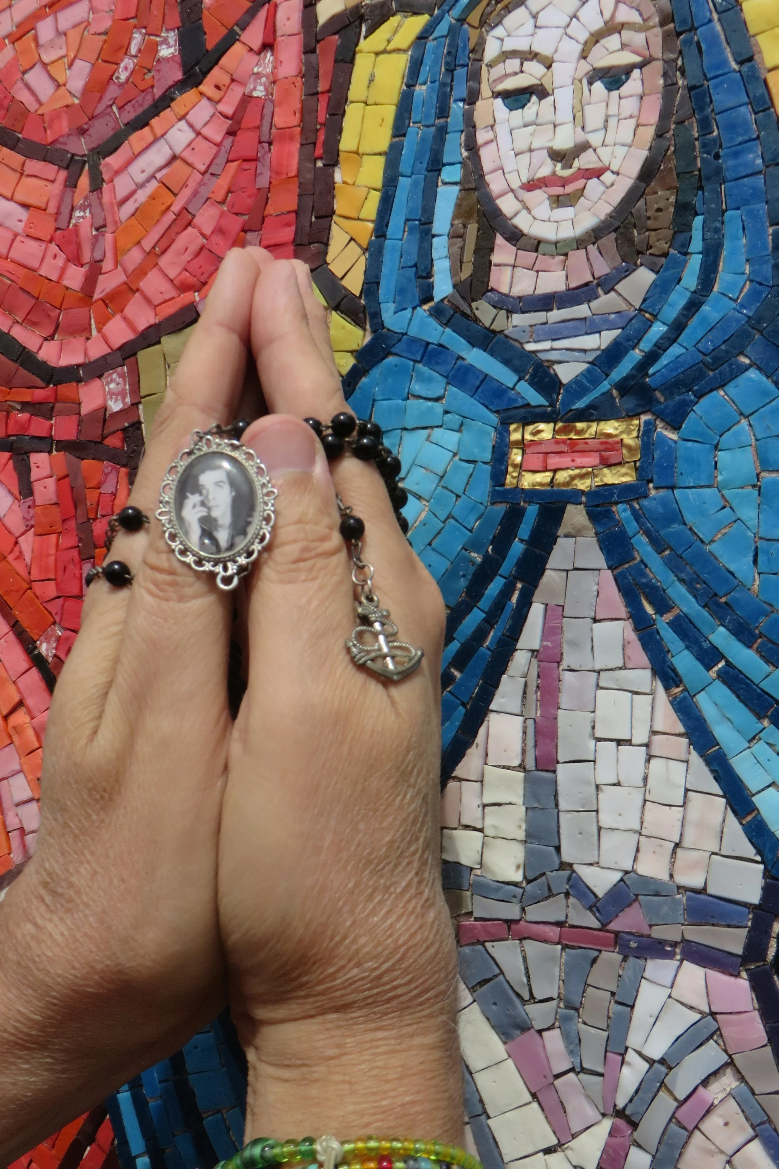
A half mile inside the county, we pulled in at Our Lady of Fatima, an outdoor shrine. It was established in 1954 by Father Louis Phillips, a priest at St. Lawrence Catholic Church in Ironton. The roadside attraction consists of a small circular pond surrounding a spot of land with statues representing the Virgin Mary and the three children she is said to have appeared to at Fatima, Portugal in 1917. Beyond the water is an array of 15 colorful tiled mosaics representing the “15 Mysteries of the Rosary,” key events in the lives of Mary and Jesus.
The setting is normally peaceful and ideal for prayer and meditation, but our visit coincided with the roar of a riding mower on the next door property, not to mention the half dozen or more emergency vehicles that blared past on their way to the fire.
A rack of complimentary rosaries was available for use by visitors. I’m neither Catholic nor a Believer, but I came prepared. I pulled from my pocket my own personal Nick Cave rosary. It features a tiny portrait of the singer, cigarette in hand, hanging among the decades of beads. I considered reciting something from the 1997 album, “The Boatman’s Call,” perhaps “Brompton Oratory” or “Into My Arms” (I don't believe in an interventionist God/But I know, darling, that you do) while giving little Nick a vigorous rubbing. Upon reflection, however, I thought that sounded a bit unseemly. I settled for Michele taking a photograph of my hands pressed in prayer while holding the Cave rosary next to one of the Mary mosaics.
Feeling an inner calm, we continued on our way, driving a few miles east into the county seat of Ironton. We went southwest on Park Avenue before turning onto South 4th Street and parking next to the Lawrence County Courthouse. The current building went up in 1907 after the previous courthouse burned. It was designed by Richards, McCarty & Bulford in a Neoclassical style and is topped with an eye-catching dome.
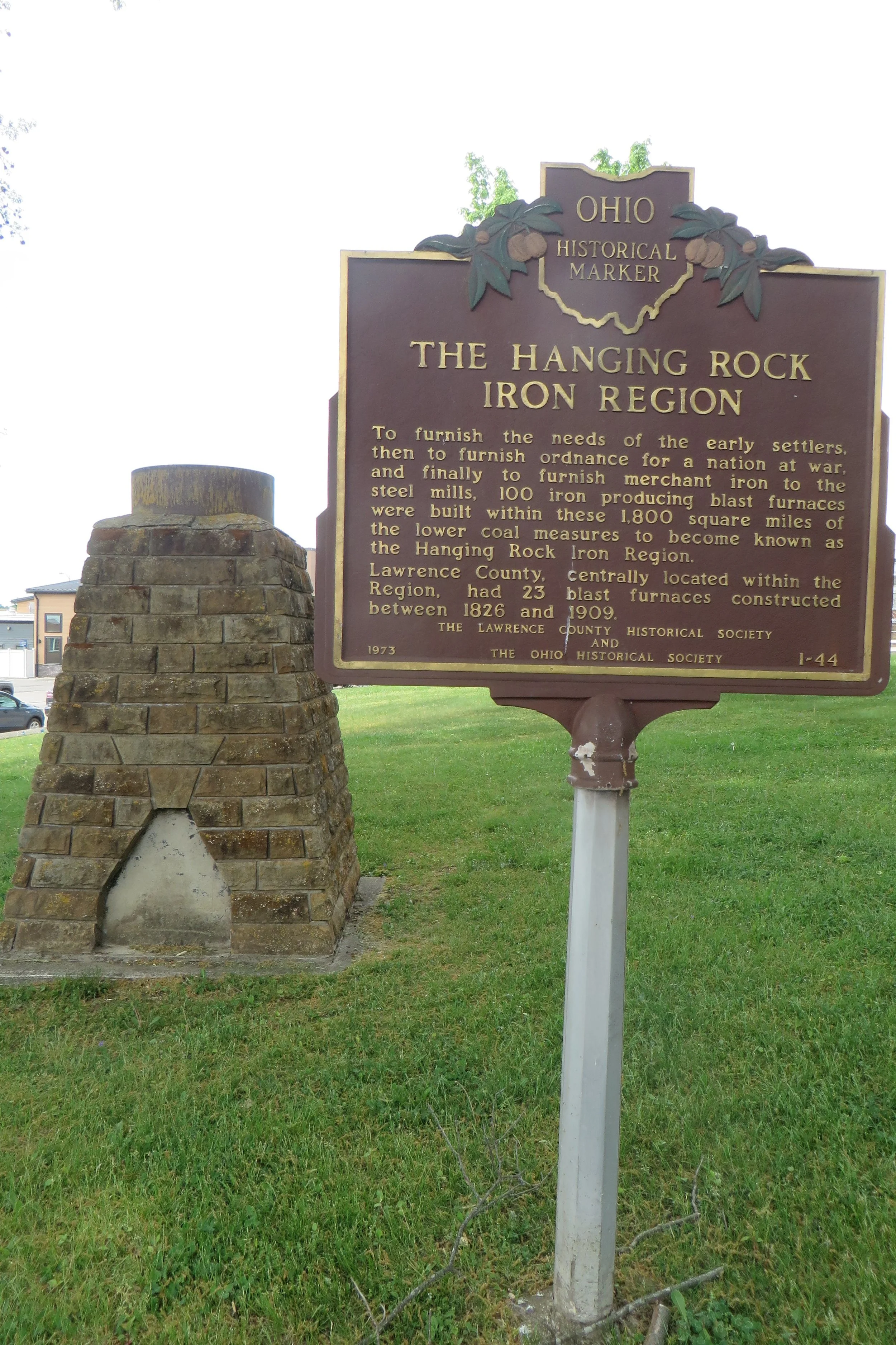
An historic marker on the courthouse lawn commemorates the Hanging Rock Iron Region, an 1,800 square mile area that helped supply the country’s iron for most of the 19th century. Of the region’s 100 blast furnaces, 23 of them were located in Lawrence County. The appropriately named Ironton, founded in 1849 on the Ohio River, served as a major transportation hub for moving iron ore to markets downriver. Next to the marker sits a replica of a furnace so diminutive that one might believe its measurements had been jotted down on a napkin by Nigel Tufnel.
We walked up and down Center Street where quite a few buildings are over a century old including three churches: St. Paul’s Lutheran Church (1904), St. Lawrence Catholic Church (1892) and First Methodist Church (1893). There’s also the former Goldcamp’s Hardware Building (1892) at the corner of Center and 4th that still sports a wraparound neon sign advertising the company that went out of business in 1993.
Moving closer to the river, we crossed Bobby Bare Boulevard, a two-block-long road renamed in 1993 for the country singer and Ironton native. It’s the last street before the Ironton Floodwall, a barrier erected after the 1937 flood that submerged three quarters of the city. A sign on the wall with that event’s high-water mark graphically reminds folks how far the water rose before cresting at 70 feet, 5 inches.
A series of murals painted on the river-facing side of the concrete wall depict people and events from the county’s history. They included local veteran William Lambert, the second-ranking American ace of World War I, Nannie Kelly Wright, thought to have been the only female ironmaster in the United States, and the Waterloo Wonders high school basketball team (more on them later). After perusing the wall art, I walked down to the water’s edge and dipped the toe of my shoe into the Ohio River, guaranteeing my return some day.
I wasn’t conscious of the railroad tracks next to the floodwall until the crossing gates came down, momentarily blocking us from our car. Fortunately, our wait was a quick one as the passing train consisted only of the engine.
We left the center of town behind and drove southeast on 3rd Street for a mile to Koun’s Korner, a locally-owned and family-operated coffee shop. It also offers boutique clothing and other eclectic items. The after-school crowd kept the staff busy, but they remained friendly as they prepared our requested iced mocha with coconut milk and hot caramel macchiato.
Continuing on 3rd, we crossed over Ice Creek, left the city limits, and immediately entered Coal Grove, Ironton’s neighboring community. We made a quick stop at the Village Pantry to pick-up milk for morning coffee before proceeding to our weekend lodging. “The Modern Sunset” is a 3-bedroom Airbnb house on Sunset Drive. It was clean, well-furnished, and felt comfortable from the moment we stepped inside. We had about an hour to relax before leaving for the next item on our travel agenda.
We drove seven miles further south along Route 52, before turning off onto Delta Lane. After another half mile, we found South Point High School, a beautiful large campus built just over a decade ago. We each paid a $7 admission fee and were in time for the 5:30 p.m. first pitch as the South Point Pointers boys baseball team hosted the Fighting Tigers of Ironton. We sat on the bleachers on the side of the home team.
The Pointers took a 2-run lead in the bottom of the first inning, but that was as much as their offense was capable. Ironton tied it up the following inning, took the lead with three more runs in the third, and proceeded to add insurance runs in the fifth and seventh innings. It wasn’t much of a contest, but it was a good place to learn some new high school baseball slang. “Bring the brisket, son,” I overheard one of the South Point players yell encouragingly to a teammate. “You gotta shake it before you bake it,” an Ironton ballplayer shouted from his dugout. The visitors also performed some synchronized handclapping when their team was up to bat. It must have had some effect as the Fighting Tigers dominated their opponents in a 13-2 victory.
High schoolers only play seven innings, but the game felt as though it was taking foooooreeeeever. I would suggest adding a pitch clock as they recently did in college and professional ball. Two and a half hours had passed by the time Ironton scored six runs in the top of the seventh. We’d had enough AND were getting hungry, so we beat the crowds by leaving before the game’s end (although one might argue it was over in the third inning).
We returned to Ironton and parked outside The River City Depot on Bobby Bare Boulevard. Not only was I interested in this restaurant due to its location in a 1906 Norfolk & Western railroad depot, but I was also intrigued by its blend of American and Japanese cuisine, offering steak and burgers as well as sushi and hibachi noodles. Alas, it was not to be. We were informed by the hostess that there would be a delay in seating, perhaps a half hour or longer, due to a lack of clean silverware! (Say wha?!)
Fortunately, another dining option was only a block away on South 2nd Street. Not only were we seated right away at Melini Italian Ristorante, but we were brought complimentary bread with marinara dipping sauce AND clean cutlery. This turned out to be a wonderful choice. I started my meal with a delicious bowl of New England Clam Chowder and followed that up with the savory Penne a Salome, prepared with peas in a pink sauce of marinara and cream. Michele enjoyed the Chicken Piccata with capellini pasta. When our bread ran out, our server brought us another plateful without our asking. We returned to our Airbnb full and with enough leftovers for another meal.
After a good night’s sleep, we began the next morning with a pot of coffee before heading back out on the road. We traveled southeast on Route 52, passing the turnoff from the previous evening’s baseball game, and drove into South Point proper. Along the main business route of Solida Road, we found The Shakery Eats and Treats, a friendly and inviting eatery with simple fare. Michele had a cheeseburger with a side of onion rings while I ordered a footlong hotdog covered in a delicious coney sauce that the restaurant also sold by the jar. I added to that a cup of the bean & cornbread soup.
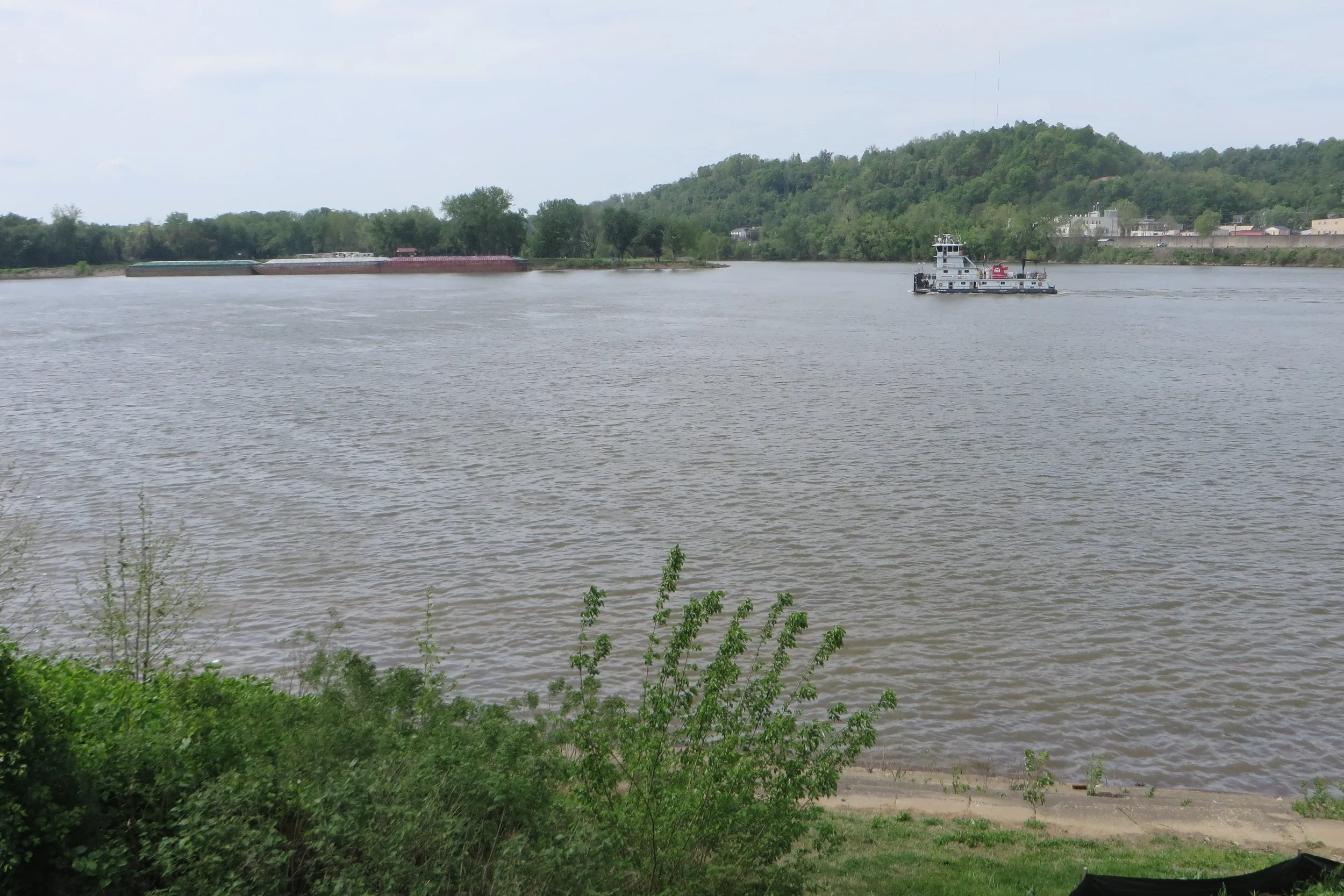
We continued down Solida Road, and then Ferry Street, before stopping at a small park next to the Ohio River. This green spot is known as the Three State Overlook. Views include Ohio in the foreground and Kentucky and West Virginia, divided by the Big Sandy River, on the far shore. Our arrival coincided with the passing of The Louisville M/V, a slow-moving towboat owned by the Marathon Petroleum Company. The flat-bottomed boat is usually used to push barges along the river, but it was traveling solo that morning.
You’d be forgiven for believing that South Point marks the southern most point in the state. Its welcome sign even says, “Southern Most Point in Ohio,” but that distinction actually goes to a spit of land less than a mile southeast of the town limits. I guess it can get away with the boast because South Point is factually the southern-most incorporated municipality in Ohio. It’s all about semantics.
After taking a few pictures, we were back in our car when a woman arrived accompanied by a couple of pointer dogs. The park must be a favored spot for them to run around in the grass. Despite the pointer being the local school mascot, I never imagined I’d see one during our visit. (Should I have been on the lookout for real-life fighting tigers in Ironton?)
We left South Point behind and drove north up Solida Road for a few miles before turning east onto County Road 144. For the next half mile, the road maintained a constant ascension until reaching Macedonia Ridge. At the road’s intersection with County Road 120, we found the Macedonia Missionary Baptist Church. This simple rectangular clapboard structure with a bell tower holds an important historic heritage. The area had been a sanctuary for escaped and freed slaves since 1799. The Baptist congregation that organized in 1811-1813 built the current structure in 1849, making it the only extant antebellum Black Church in Ohio. An ongoing restoration project hopes to preserve the building and return it to service as an historic site and community center. Comparing the dilapidated church that appeared in a year-and-a-half-old Google Street View to what we saw in person, it was obvious that impressive progress had been made.
Descending from the ridge on Burlington-Macedonia Road, I used my odometer and a county map to ensure a correct turn onto Charley Creek Road because there sure weren’t any identifying road signs. Back at Route 52, we continued east to Chesapeake, another riverside town. We pulled over on 3rd Avenue so I could take a picture of the Symmes Creek Bridge.
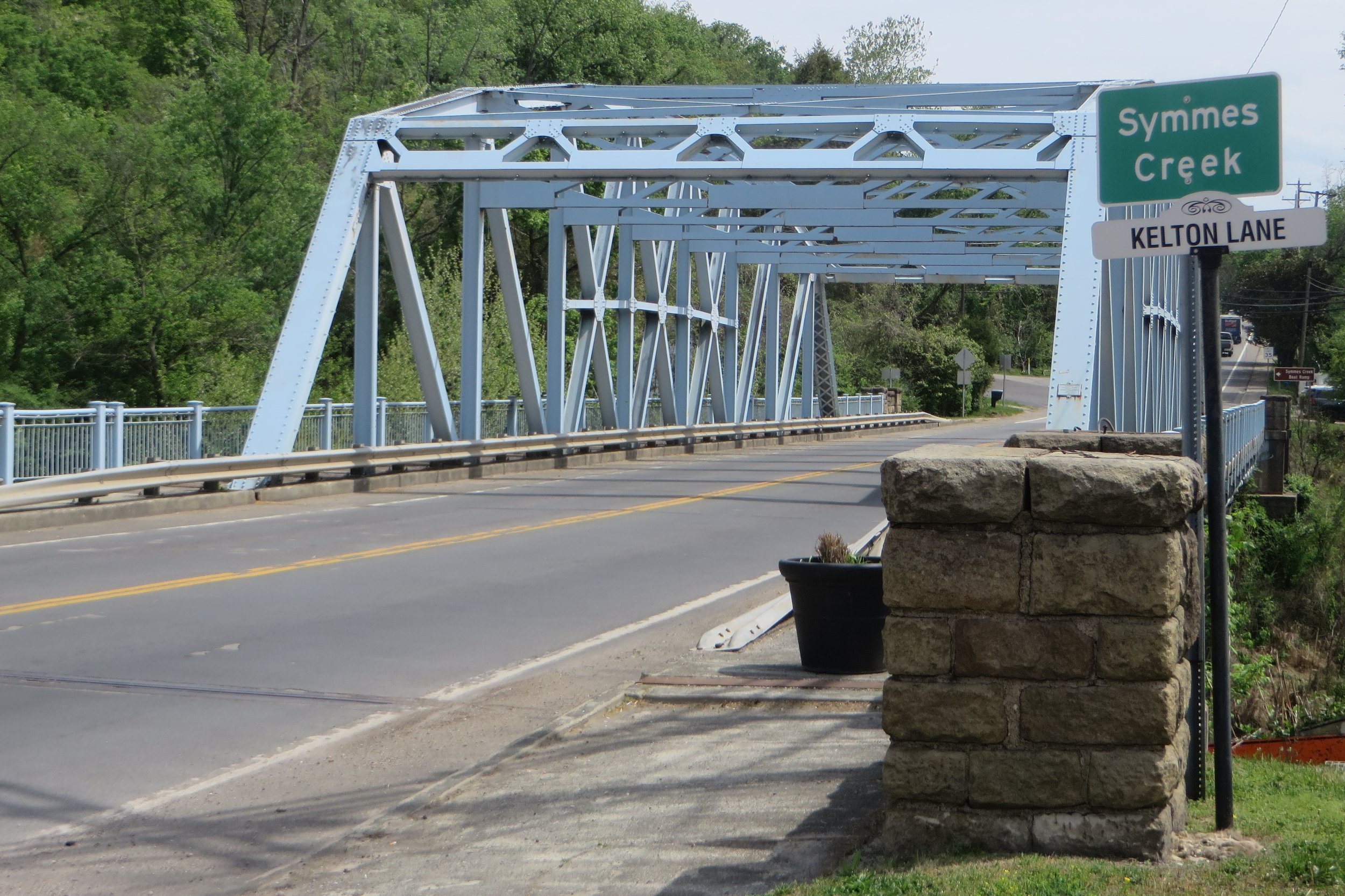
This 348-foot-long metal span is nearly a century old, having been built in 1933. Its design is characterized as a Parker riveted through bridge and is known by its polygonal/curved top chord. Its blue color came from a fresh coat of paint in 1993.
The bridge carries traffic along State Route 7 which we continued to follow east a few miles to the neighboring village of Proctorville. At that point, we turned north onto State Route 775. As we drove in the opposite direction from the Ohio River, the road became hillier and more winding.
After nearly ten miles of a roller coaster drive, we turned east onto State Route 217. Another half mile took us to the Scottown Covered Bridge. Built in 1874 over Indian Guyan Creek, the 79-foot-long bridge is the only existing covered bridge in the county. The original design was a Multiple Kingpost Truss, but after being reinforced with cables and rods in the 1930s, its truss could be more accurately described as “mongrel.” The roof and floor were replaced in 1991, and it no longer allows vehicular traffic, but its original frame is still intact and available for close inspection by pedestrians.
Reversing course on OH-217, we drove west for about seven miles, spotting a half dozen wild turkeys in a field along the way. Just past the unincorporated community of Linnville, we parked next to an old red barn. On its side, faded and chipped, but still visible, was the Ohio Bicentennial logo. It was a festive occasion when on August 22, 2002, artist Scott Hagan made it his 86th of 88 barn paintings. On that day, hundreds of people pulled up lawn chairs to watch the three-colored logo be applied to the barn. There was entertainment and door prizes as well as refreshments provided by the Lawrence County 4-H clubs. On that day, watching paint dry became a party! It was much quieter during our visit. As I snapped a few pictures, not another car passed and only the occasional singing bird made a sound.
We backtracked on OH-217 for a mile before turning north onto State Route 378. A few miles farther, we connected to State Route 141. We passed sheep grazing on a hill and the campus of Symmes Valley High School as the clouds overhead began to darken. We stopped at the intersection of OH-141 and State Route 775 to see one of those roadside oddities that county trips are made for.
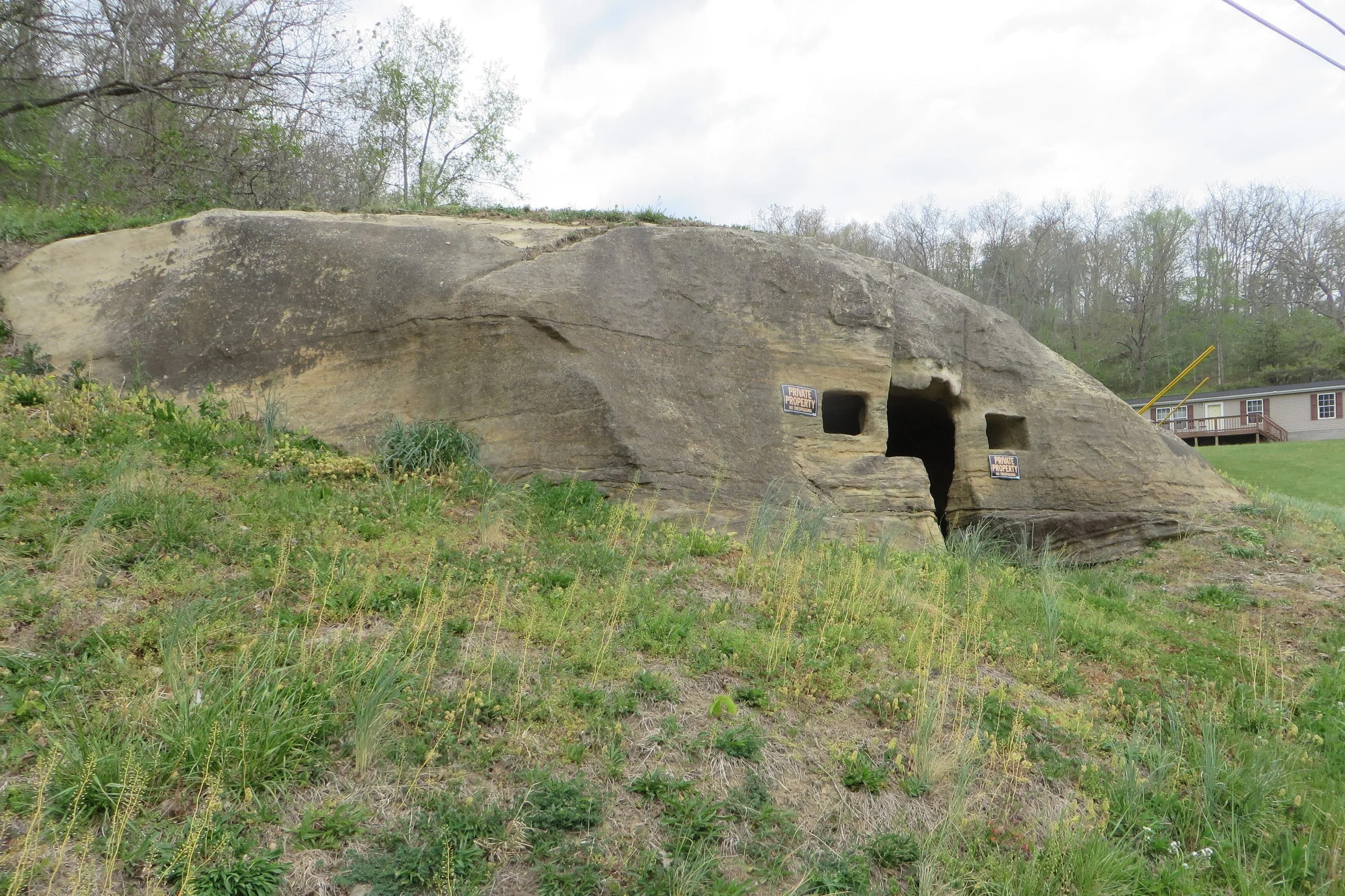
On the north corner sits a large sandstone boulder that has been hollowed out. Origin stories vary, but I found a 2004 newspaper article that provided some history. The owner at that time claimed the cave house dates to 1847 when then-owner John Russell paid two men $50 to dig out with picks and shovels a 12-foot by 14-foot room. It contains a doorway, two windows, and a topside vent. “Private Property No Trespassing” signs are posted outside, but the 2004 owner claimed those were meant to keep children out who he feared might fall off the top and hurt themselves. I can’t help but think that over the course of the past century and a half, more than a few underage kids enjoyed some adult beverages inside while singing along to songs by the Stones, Elvis, Bessie Smith, and, um, Stephen Foster?
We continued north on OH-141 for another six and a half miles to the community of Waterloo. It leans up against the county border and may even spill over if you’re not careful. Soon after crossing Symmes Creek, we turned onto Waterloo-Mt. Vernon Road, rounded a corner, and then parked next to the WOW Ministries Church. That’s where we found the historical marker commemorating the Waterloo Wonders.
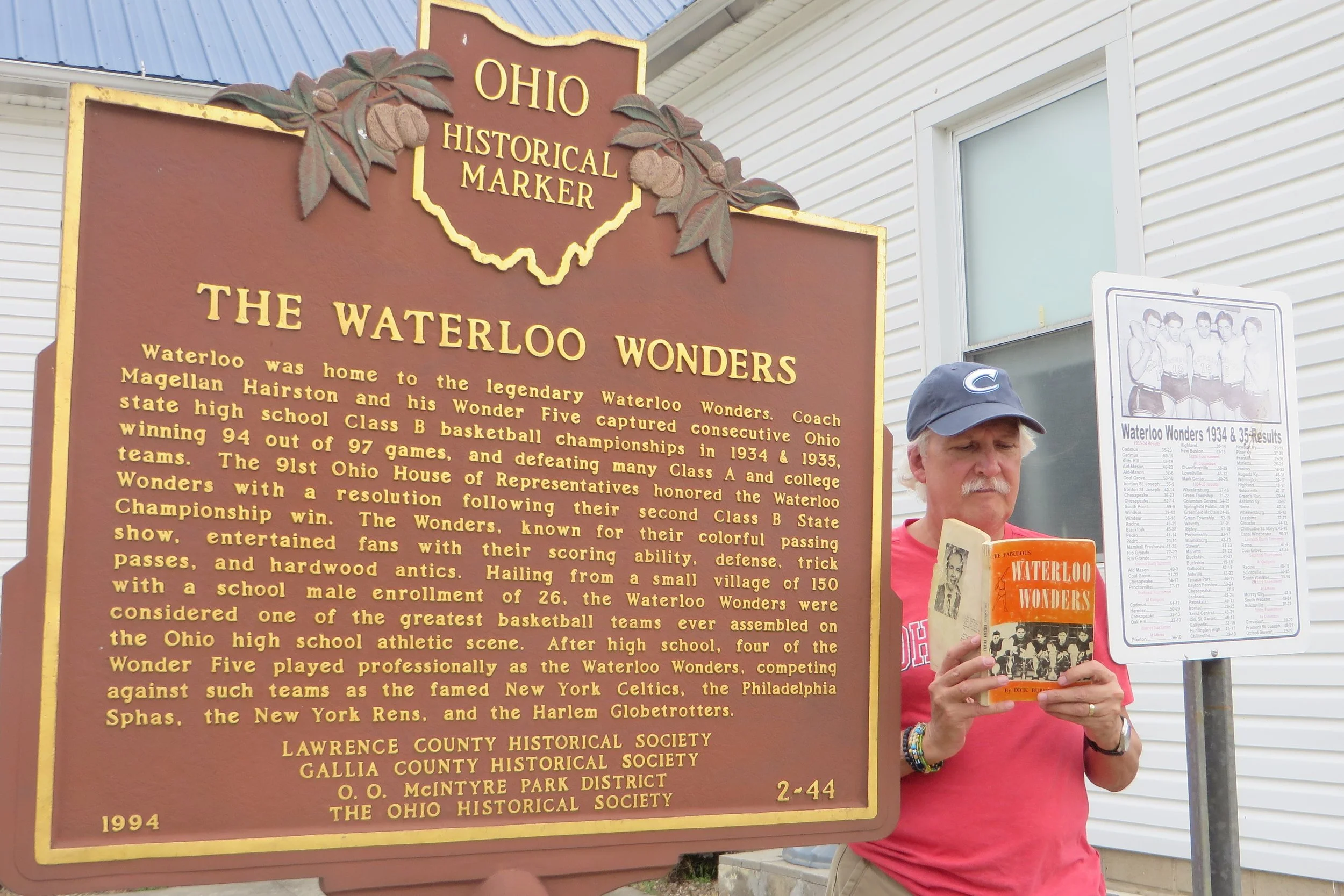
During the Great Depression years of the 1930s, the Waterloo High School boys basketball team won the Class B State Championship in 1934 and 1935. This fact alone does not amaze, but a deeper dive into the story does. At the time when only 26 boys attended the poor, rural high school, the five starters of that basketball team not only consistently dominated their opponents, but they did so with a talent and flair that resembled later performances by the Harlem Globetrotters. The Wonders were adept not only at scoring, but also passing and ball handling that kept dribbling to a minimum. The players also had fun. Stories passed down of hot dog eating during a time out and shooting marbles in the center circle. The team was good and confident and often beat Class A schools as well as some college teams.
The legend of the Waterloo Wonders was one I grew up with. My father was only a few years younger than those cagers, and a high school basketball player himself, so their story was a big part of his youth. He passed their story on to me as well as the 1961 book, The Fabulous Waterloo Wonders by Dick Burdette. I made sure to bring that book along with me for my personal photoshoot at the marker. I think my dad would have liked that.
The picture was taken just in time. As we reversed course back south on OH-141, big fat raindrops began splattering our windshield. We passed back through the unincorporated communities of Arabia, Wilgus, and Aid. At the latter, we pulled over as a funeral procession passed, probably heading to the hilltop Aid Cemetery.
We remained on OH-141 for another ten miles as it bobbed and weaved its way across Lawrence Township. The rain alternated between brief downpours and an occasional dribbling. Housing became more prevalent as we entered the community of Hecla. Just past Skeeto’s Pizza, we pulled into the parking lot for Gone Fishin’ Live Bait & Tackle. I wasn’t in the market for any angling supplies. I just wanted to take a picture of the exterior wall mural depicting a fish getting caught by an oversized 3-dimensional fishing rod.
‘Cause that’s what we do on county trips!
The rain had stopped by the time we arrived back in Ironton around 2:45 p.m. I was hoping for the best when we parked downtown near South 3rd and Vernon Streets. A couple of local shops were hosting “Spring on Vernon,” a little city festival, scheduled from 9 a.m. to 4 p.m., where vendors set up shop on a two-block stretch of Vernon Street that was closed to motorized vehicles. The advertising promised appearances by the “Easter Bunny and Friends.” Unfortunately, the afternoon showers must have put a damper on the event because by the time we arrived, the street was back open to traffic and there were no longer signs of any outdoor retailers (or the Easter Bunny!).
A cool, damp pall had fallen on the afternoon, so we returned to our Airbnb to kick-back and warm-up. A pot of coffee helped on that second matter. When we eventually began to feel peckish, we pulled out the leftovers from the night before and were happy to discover that Melini’s dishes were just as delicious warmed-up.
As we spent the evening watching television, I multi-tasked by checking online stories from the local newspaper’s website. My attention was immediately drawn to The Ironton Tribune’s headline, “Maryland man killed in Lawrence County plane crash.” A paywall blocked me from more information but another news source confirmed my uneasy suspicions: “According to Lawrence County 911 dispatchers, the crash happened around 2:15 p.m. when a single aircraft, later identified as a 1987 Mooney M20, crashed in the 100 block of County Road 1A along the Lawrence-Scioto county line near US-52.”
That was the source of the black smoke and fire we witnessed when entering the county the day before. Pilot David S. Wade, from Salisbury, Maryland, was pronounced dead at the scene. He was the only person aboard the plane that had departed just shortly before from the Ashland Regional Airport in Worthington, Kentucky, across the Ohio River, and was heading to Kansas. The cause of the crash wasn’t immediately known.
It’s an odd and somewhat perplexing feeling to be in such close proximity to a deadly accident that otherwise, has no personal connection.
We didn’t sleep-in quite as long as we might have wished the following morning as we had an early 10 a.m. check-out and we wanted to ensure we had time for our morning coffee! We made sure though, to use up each of our entitled minutes in the 9 o’clock hour before departing.
All packed up, we jumped on Route 52 for another trip back to Ironton, but instead of driving into the city proper, we exited north onto Park Drive for 1,000 feet before U-turning up Nixon Hill Road. That led us straight to the Historic State Route 75 Tunnel.
A century and a half ago, Cronacher’s Hill was an impediment for easy transportation of iron being shipped from the furnaces north of the city to the Ohio River. In 1866-67, a tunnel was excavated through the hill. It was enlarged in 1915 and officially became a part of State Route 75 nine years later. Automobile traffic was halted through the tunnel in 1960 when it was bypassed in a realignment of the state route. (State Route 75 was renumbered State Route 93 in 1962.) The tunnel was reopened as a pedestrian tourist attraction in 1989. A decade later, it was converted into a “haunted tunnel” for Halloween and has since served as a money maker for the Lions Club.
Since we were visiting out of season, we couldn’t get past the locked gates at the entrance, but we were able to climb the rickety weathered wooden stairway to the top of the hill above the tunnel. The Sunday morning wind was a cold one, but the view from the top was worth bearing it. A southward vista includes the dome of the courthouse as well as the hills of Kentucky on the far banks of the Ohio River. I turned my head slightly to the east and could see through a hole in the tree line the two tall white towers of the Oakley C. Collins Memorial Bridge that connects the two states.
Returning to Park Drive and heading southward, we still had some time to kill before our lunchtime restaurant opened, so we cruised around some of Ironton’s streets looking for historical homes and other points of interest. The first was an attractive two-story Queen Anne house made of Indiana stone at 504 South 5th Street. It was built in the early 1900s, but it wasn’t until ironmaster (and future floodwall mural honoree) Nannie Kelly Wright took possession in 1918 that it acquired its name Bide-A-Wee, a Scottish phrase meaning, “stay a while.”
A block away at 506 South 6th Street is the Colonel George N. Gray House, a three-and-a-half story Victorian-Italian Villa brick structure. It was built in 1870 by James and Elizabeth Ferguson, but was greatly remodeled by the Gray family who owned it for nearly a century so it’s for their progenitor that it’s named. Since 1988 it has been owned by the Lawrence County Historical Society and currently houses its museum.
We drove south for nearly a mile to check out the adjoining school properties of Ohio University Southern, a satellite campus for OU, and Ironton High School. During football season, the Fighting Tigers host games in Tanks Memorial Stadium. The sports venue was built in 1926 for the Ironton Tanks, a semi-professional football team that ceased operations after their 1930 season. It remains one of the few roofed high school stadiums in the country. (To be clear, it’s the home-side grandstands that are covered, not the entire stadium.)
Heading back north along 9th Street, we passed a man setting up for a yard sale. He had three chainsaws out on display. Was he a former arborist? Forest ranger? Gruesome murderer from Texas? We didn’t have time to ask as it was lunchtime.
We parked outside of Armory Smokehouse just as they were opening their doors for the day. Housed in the former Ironton National Guard Armory that had first opened its doors in 1937, the restaurant displays various photographs and artifacts relating to its military heritage, including that of the 216th Engineering Battalion, an historic Ohio Army National Guard unit that once called the building home. The restaurant also serves up some excellent BBQ! Both Michele and I ordered the brisket – an Armory favorite – accompanied by a spicy sauce that was peppery and flavorful. I added to my entrée helpings of smoked mac & cheese and green beans while Michele selected potato salad and broccoli as her sides. The busy waitstaff were friendly and efficient. We committed the spot to memory in case we should again find ourselves in the neighborhood.
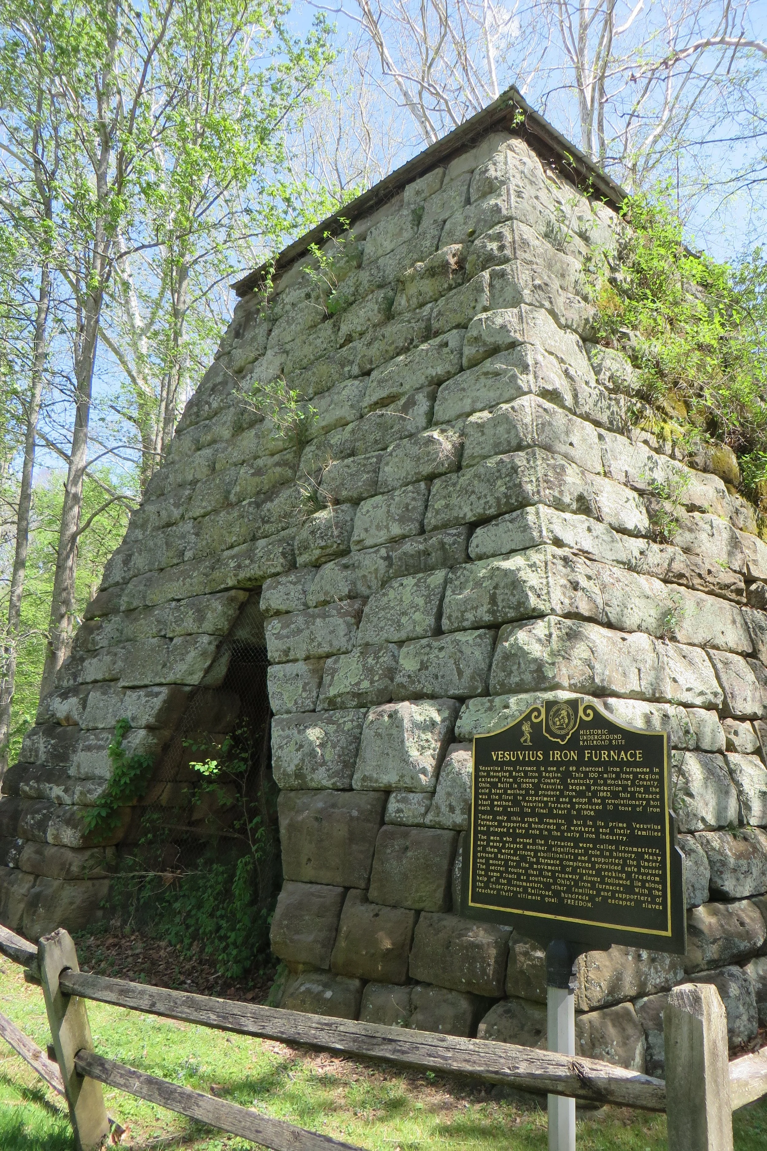
After lunch, we pointed the car north on State Route 93 and were essentially heading out of the county, but we still had a few stops to make before the trip was completed. Six miles north of Ironton, we entered Wayne National Forest before turning east on Paddle Creek Road. Another mile took us to Lake Vesuvius Recreation Area. Near the lake and picnic area are the stone remains of the area’s namesake, the Vesuvius Iron Furnace. I learned from its historic marker that it was built in 1833 and originally used a cold blast method to produce iron. It later became one of the first furnaces to experiment with and adopt the revolutionary hot blast method. It produced 10 tons of iron a day until it closed in 1906.
I had mapped out a 2 ½ mile hiking route that would incorporate part of the Lakeshore Trail and all of the Whiskey Run Trail. A Carolina wren chirped a greeting to us as we climbed a set of cement steps to the trailhead. I’d seen a warning on the Forest Service website that the water level of the 143-acre lake would be lower than normal so they could repair the dam gate that was unable to close due to either debris obstruction or malfunction, but I wasn’t prepared for the sight we came upon: a totally drained reservoir. The parched brown lake bed resembled a desert scene.
The first half mile or so of our hike was extremely slow going, not due to any kind of strenuous terrain, but because Michele was constantly stopping to marvel at different trailside wildflowers. If your goal is to get from Point A to Point B as fast as possible, you might find this sort of interruption annoying, but if so, you’d be missing out on A LOT of interesting nature. I tend to enjoy looking up at interesting rock cliff formations and the occasional mushroom growth on a log, but if it wasn’t for Michele, I’d miss all the tiny and fascinating and colorful growth closer to the ground. (Feel free to crank up “The Whole of the Moon” by The Waterboys at this point.)
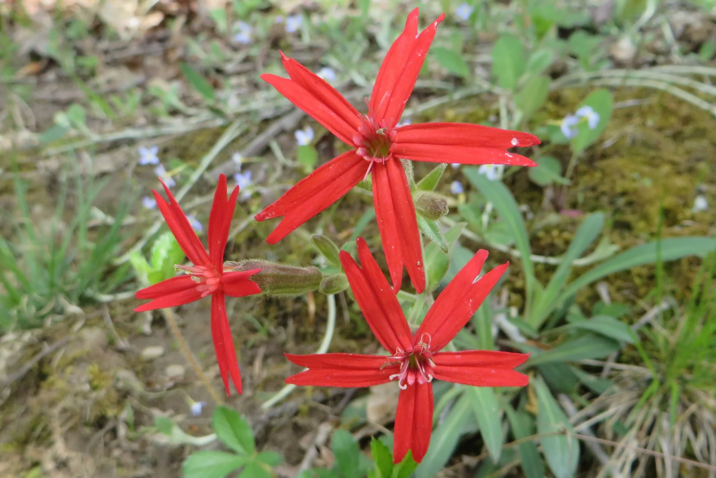
It was the prime time of year to find a lot of these blooming wildflowers, too! Michele knew the names of many from sight, but for those she didn’t know, she took pictures and later used her wildflower book and the internet to identify them. We listed over a dozen finds without even trying. Colors dominated in the form of red 5-petal fire pinks, bluets, and dwarf crested irises (also blue), the blue bell-shaped Jacob’s Ladder, the purple wood betony, and the yellow two-flowered Cynthia. Other wildflower varieties we saw included trillium, spring beauty, white and purple violets, wild stonecrop, foam flower, wild geranium, wild azalea, and the mayapple where the plant’s single white flower can be easily missed because it hides under its umbrella-like leaves. Michele also identified a Jack-in-the-pulpit flower, but it hadn’t yet bloomed, so technically, Jack had yet to enter the pulpit.
We also heard and/or saw a chipping sparrow, red bellied woodpecker, bluejay, song sparrow, tufted titmouse, chickadee, and nuthatch, but the stars of the day were definitely the wildflowers.
Back in the car, we returned to OH-93, drove another 1.3 miles before turning onto Etna-Waterloo Road. We only drove a half mile before finding the Little Etna Furnace by the side of the road. It was indeed little. It operated from 1832 to 1887.
Another 13 miles along OH-93 took us through Elizabeth and Decatur Townships and just barely into Washington Township before we found the remains of the Olive Furnace. Actually, the remnants are hidden quite well within the roadside foliage and we could have easily missed it had its historical marker not been planted close to the road. This blast furnace was established in 1846 and is reported to have served as a stop on the Underground Railroad. I could just barely make out its remaining Roman style arch that was used as a support for the furnace. It closed down in 1915 and holds the distinction of being the last charcoal furnace to operate in Lawrence County.
It was also the last site on our county agenda. We drove on for another six miles before being blown out of the “smokestack” at the top of the county.
Time spent in the county: 48 hours, 47 minutes
Miles driven in the county: 159